Map Preparation
 If your map has light blue tick marks along the edges,
rather than a full UTM grid,
you'll have to connect them to make a grid.
Folding a map makes it more portable.
Maps we sell can include a UTM grid and/or folding for no extra charge,
or you can do these things yourself.
If your map has light blue tick marks along the edges,
rather than a full UTM grid,
you'll have to connect them to make a grid.
Folding a map makes it more portable.
Maps we sell can include a UTM grid and/or folding for no extra charge,
or you can do these things yourself.
All you need are a flat surface, a sharp pencil, and at least a two foot
ruler. A mechanical pencil and drafting ruler are best:
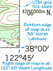
Locate two of the light blue tick marks on opposite
edges with the same number, like "4206000m", or "4206" (without the last 3
zeroes). Carefully place the ruler near the two marks,
and test the pencil to make sure it will land on the tick mark at both ends.
Move your non-pencil hand to the middle of the ruler and press down firmly to
keep everything in place. Slowly draw in the grid line. You may want to draw
lightly at first to get the hang of it.
Draw in the remaining parallel lines.
Some ticks may not be numbered,
so be sure to start with a numbered tick mark.
Now turn the map 90 degrees,
connect the tick marks along the other two edges,
and you have a complete UTM Grid.
When you're done gridding your map, you may also want to fold it:
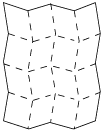 On the same flat surface, match up two opposite edges and fold.
Now, fold each edge back to the middle fold,
making a 4-section "fan".
On the same flat surface, match up two opposite edges and fold.
Now, fold each edge back to the middle fold,
making a 4-section "fan".
Unfold the map, turn it 90 degrees,
and make the same folds as before.
This prepares the map to fold in any direction.
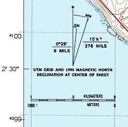
For better accuracy, you can use a calibrated scale or plastic "Grid Roamer"
to read between the grid lines.
Roamers for 1:24,000 scale maps
are available from many of the same stores which sell USGS maps.
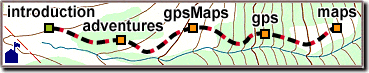
Most maps and gpsMaps ordered from
Wild Rose can include a Grid Roamer for $10.
|

 Angular coordinates can specify any location on Earth,
usually in Degrees of Latitude and Longitude.
A degree (1/360th of a full circle),
is divided into 60 "minutes" (1/60th of a degree), and
a "minute" can be further divided into 60 "seconds".
Angular coordinates can specify any location on Earth,
usually in Degrees of Latitude and Longitude.
A degree (1/360th of a full circle),
is divided into 60 "minutes" (1/60th of a degree), and
a "minute" can be further divided into 60 "seconds".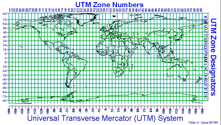
 UTM is a metric system with many advantages over angular coordinates.
Almost all large-scale USGS maps have UTM markings
for quick and accurate position readings.
UTM is a metric system with many advantages over angular coordinates.
Almost all large-scale USGS maps have UTM markings
for quick and accurate position readings.
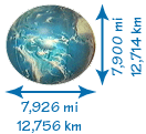 Mapping is never an exact process.
The Earth is not quite a sphere,
or even a flattened ball.
This makes measuring coordinates and altitude far more difficult.
Mapping is never an exact process.
The Earth is not quite a sphere,
or even a flattened ball.
This makes measuring coordinates and altitude far more difficult. To use a map and GPS receiver together,
set your receiver to
use the same datum as your map (usually NAD27-CONUS).
This is important, since your GPS receiver may default to WGS84,
a good choice when working without a map.
To use a map and GPS receiver together,
set your receiver to
use the same datum as your map (usually NAD27-CONUS).
This is important, since your GPS receiver may default to WGS84,
a good choice when working without a map.