Compass
 Most people making or using maps would feel lost without a compass.
Map and compass skills are easy to learn,
and there are many references available.
Most people making or using maps would feel lost without a compass.
Map and compass skills are easy to learn,
and there are many references available.
Books on GPS spend whole chapters
explaining what to do if your batteries run down,
your map blows away, or you're lost with
no one but a friendly pack of wolves to guide you.
The message, of course,
is to never depend on one method of navigation.
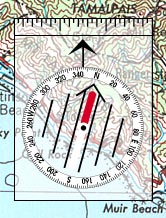
A mirrored or sighting compass can improve accuracy.
Also, the compass must be far away from iron or steel objects:
A few feet to a meter away from small objects
like a flashlight or pocketknife,
20 to 50 meters (or yards) from larger objects like
cars, buildings, or powerlines.
You can use a GPS receiver to find direction,
but a compass is usually easier and more accurate.
If you're not moving at least 10 miles per hour,
a GPS receiver may show your direction of travel incorrectly.
|
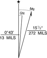 Magnetic North usually isn't the same as True North
because Earth's magnetic poles are hundreds of miles
from the "true" North and South poles.
A correction angle called "Magnetic Declination"
is often shown on a map.
Declination varies from place to place, and slowly over time.
Magnetic North usually isn't the same as True North
because Earth's magnetic poles are hundreds of miles
from the "true" North and South poles.
A correction angle called "Magnetic Declination"
is often shown on a map.
Declination varies from place to place, and slowly over time.
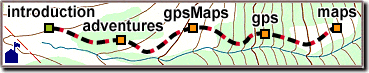
 You can make your own maps
using just a compass and some way of measuring distance.
You can also use a hand-drawn map to supplement your GPS readings.
You can make your own maps
using just a compass and some way of measuring distance.
You can also use a hand-drawn map to supplement your GPS readings.