|
|
 |
| accuracy |
|
|
|
|
GPS Accuracy
 With good satellite coverage,
the location displayed by your GPS receiver
should be accurate to within 50 meters
(164 feet) about half the time.
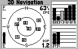
Most receivers show "Estimated Position Error" (EPE),
"Dilution of Precision" (DOP), or both,
but these are only esimates based on satellite coverage and geometry.
With good satellite coverage,
the location displayed by your GPS receiver
should be accurate to within 50 meters
(164 feet) about half the time.
Most receivers show "Estimated Position Error" (EPE),
"Dilution of Precision" (DOP), or both,
but these are only esimates based on satellite coverage and geometry.
Many things can degrade the accuracy
of GPS positions. The most well-known of these is the
intentional error known as "Selective Availability",
but other errors can be far worse.
Make sure your GPS receiver is set up properly.
If you'll be using GPS with a map,
or for map-making, the datum
used by the receiver
should match the datum specified in the margin of the map.
GPS accuracy can be degraded by:
- Operator error:
GPS receiver datum and coordinate-system settings,
data entry errors like bad UTM Zone or degrees West
instead of East, transcription and map-measurement errors,
and magnetic/true bearing errors.
- Obstruction of satellite signals:
When the signal from a satellite is suddenly lost,
the receiver can get "garbage" data,
or make bad assumptions or calculations.
The same can happen as a satellite signal is restored.
GPS receivers are designed to handle these obstructions
seamlessly, but rare errors can be
hundreds of miles.
- Few useable satellites:
Less than 4 available satellites leads to a "2D mode"
position, which is less accurate.
Altitude must be assumed,
leading to horizontal errors which can exceed a mile.
- Selective Availability (SA):
See below - SA is "off", but may reappear.
This is an intentional error
to "deny accuracy" to recreational GPS users.
SA is described below,
along with some suggested solutions.
- Poor satellite geometry:
When the available satellites are in one part of the sky,
or nearly lined up, the receiver's calculations are
less accurate.
- Multipath interference:
Reflection of GPS signals from buildings
or cliffs can change signal timing,
or garble GPS data,
causing position errors.
- Atmospheric conditions:
Rain or snow can weaken signals,
but are usually not a problem.
Atmospheric refraction can change signal timing,
causing position errors.
- Satellite position errors:
Orbit and position data
for GPS satellites are subject
to "ephemeris" errors.
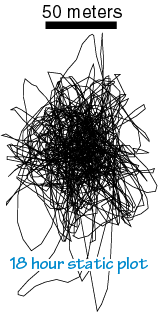
All GPS errors can "double up" if you store a position,
then attempt to relocate it later with GPS.
This is because the error when a location is marked
can add to GPS errors while re-locating the mark.
GPS altitude errors
can be 1.5 times as large as horizontal errors.
On some older receivers, a "stale" position can be shown
even with no navigation signals received.
Most of these errors are either small
or easily avoidable by knowing and operating your GPS receiver well.
|
|


 On May 2, 2000 SA was "switched off",
giving GPS users about 10 times better
accuracy, subject to all the other factors above.
Some of the following can thus be skipped, but
SA can still reappear - anytime, anywhere.
On May 2, 2000 SA was "switched off",
giving GPS users about 10 times better
accuracy, subject to all the other factors above.
Some of the following can thus be skipped, but
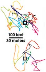
SA can still reappear - anytime, anywhere.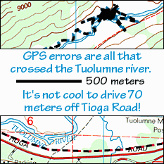 Even with SA and other errors,
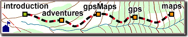
trails plotted on our gpsMaps are surprisingly clear and readable.
The
Even with SA and other errors,
trails plotted on our gpsMaps are surprisingly clear and readable.
The 
 It has been suggested that using
two GPS receivers: one stationary, the other in motion,
can reduce the effects of Selective Availability.
The stationary receiver records SA displacements,
which are then subtracted from
the readings of a second "survey" receiver.
It has been suggested that using
two GPS receivers: one stationary, the other in motion,
can reduce the effects of Selective Availability.
The stationary receiver records SA displacements,
which are then subtracted from
the readings of a second "survey" receiver.