|
|
|
Track Settings
 A track is a series of locations and times.
Some receivers can store over 1500 track points,
but track memory will fill up quickly with the wrong settings.
A track is a series of locations and times.
Some receivers can store over 1500 track points,
but track memory will fill up quickly with the wrong settings.
Before recording a three day backpacking trip,
experiment with the receiver's track settings
to find the right compromise between:
- the amount of time you'll be travelling,
- the resolution the track must have, and
- the available memory in your receiver.
Different receivers need different settings,
so we'll give some examples,
but defer to the user manual for the mechanics.
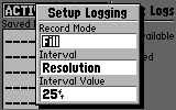
Available track logging modes may include:
- Automatic:
Makes good use of available memory,
but sometimes cuts corners or lacks resolution.
- Resolution:
An adjustable automatic mode,
making good use of available memory,
with an adjustable "resolution" setting (in feet or meters),
allowing you to trade off memory usage for detail.
- Time:
Lets you set the elapsed time (in seconds)
between recorded points,
but keeps on recording, even if you stop.
- Distance:
Lets you set the distance (in feet or meters)
between recorded points,
but can record unneeded points while
travelling in a straight line.
The "resolution" setting is usually best,
since this allows you to pick the size of the features you're mapping.
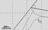
A smaller resolution (100 feet or less) produces a more detailed track,
but will use up memory quicker.
It's particularly disappointing to
record the first part of a journey with a smaller resolution,
only to miss the rest of it -
or overwrite the first part -
because the track memory is full.
For long trips, pick a large resolution (250 feet or greater).
The resulting path will be accurate,
but corners and switchbacks
can be simplified a bit.
If a resolution setting isn't provided,
choose between the others based on what you're doing
and how much recording time you need.
|
|
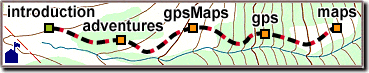
 Many GPS receivers can automatically
keep "track" of the path you travel.
This can be useful if you need to backtrack,
and most tracking receivers
can also send the track data to a computer -
either for storage, or to plot on a gpsMap.
Many GPS receivers can automatically
keep "track" of the path you travel.
This can be useful if you need to backtrack,
and most tracking receivers
can also send the track data to a computer -
either for storage, or to plot on a gpsMap.