|
|
|
|
|

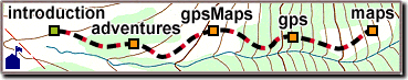
 Located along the California coast just North of Santa Cruz,
Wilder Ranch is grassy hills, ocean views, beaches and forests,
with over 30 miles of trails for hikers, mountain bikers, and horseback riders.
Located along the California coast just North of Santa Cruz,
Wilder Ranch is grassy hills, ocean views, beaches and forests,
with over 30 miles of trails for hikers, mountain bikers, and horseback riders. To be most useful and accurate, a map should not include
GPS errors,
which are discussed in the GPS section.
To get around them, trails can be recorded several times,
or in opposite directions,
so problems can be averaged out.
To be most useful and accurate, a map should not include
GPS errors,
which are discussed in the GPS section.
To get around them, trails can be recorded several times,
or in opposite directions,
so problems can be averaged out. Two problems appear on the plot at right:
The trail seems to cross the "Gulch" near the North arrow,
but this is a "spike" caused when trees obscured the GPS satellite signals.
The actual trail rounds the corner, like the double-dashed line
on the USGS base map.
Two problems appear on the plot at right:
The trail seems to cross the "Gulch" near the North arrow,
but this is a "spike" caused when trees obscured the GPS satellite signals.
The actual trail rounds the corner, like the double-dashed line
on the USGS base map. 
 Another example of a "simplified" road on a USGS map (left)
can be compared to the more-detailed shape plotted by GPS.
The horizontal line near "018" is the seam between
two different USGS "quadrangle" maps.
Another example of a "simplified" road on a USGS map (left)
can be compared to the more-detailed shape plotted by GPS.
The horizontal line near "018" is the seam between
two different USGS "quadrangle" maps. Finally, an example of what happens when there are just too many
points or trails to see clearly.
We can work with you to reduce clutter,
while still including the important stuff.
Finally, an example of what happens when there are just too many
points or trails to see clearly.
We can work with you to reduce clutter,
while still including the important stuff.
|
|
|